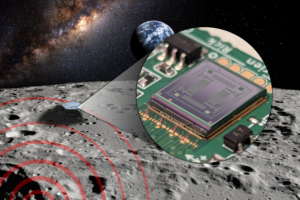
Geophysics | Seismic Imaging

Our breakthrough technology offers specialized solutions for geothermal energy, carbon capture and storage (CCS), mineral extraction, and aerospace, enhancing operational performance, cutting costs, and driving innovation and growth across these industries. 

The demand for highly accurate data and compact electronics is on the rise. However, balancing precision and miniaturization at efficient prices is still a challenge in increasingly important industries like geothermal energy, carbon capture and storage, mineral sourcing and aerospace. Here miniaturization plays a crucial role as the amount of equipment in the field directly impacts the operational expense and environmental impact. As the European Union prioritises climate change mitigation, overcoming these technical and economic barriers is essential for meeting climate goals.


Seismic imaging offers a solution, enabling the visualization and mapping of underground structures without the need for drilling. It works by generating seismic waves, using specialized equipment like vibrators, and recording how these waves interact with the Earth’s layers. When the seismic waves encounter different rock formations, they reflect and refract, creating data that is captured by seismic sensors on the surface. This data is then processed to create detailed images of underground structures, such as fault lines, or geothermal resources. Seismic imaging is crucial as it helps identify and understand subsurface formations without drilling.


Applications

  • Geothermal Energy
  • Carbon Capture & Storage (CCS)
  • Mineral sourcing

Use Cases ( copied from ESA file)


  •  

News & Achievements